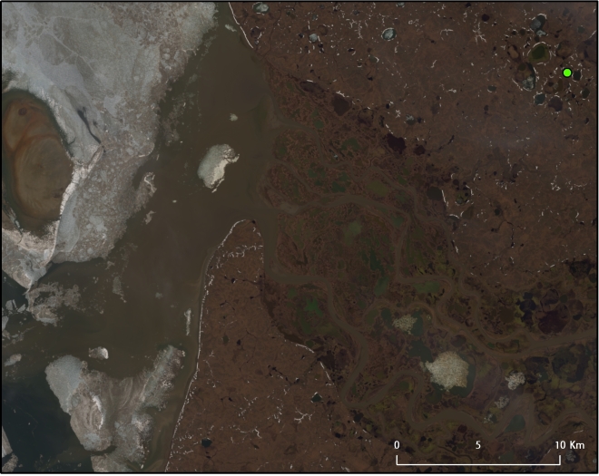
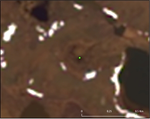
Featured image: The crater in Yamal seen from space in 30-meter Landsat 8 imagery. Check out more images below.
When helicopter pilots spotted a mysterious, gaping hole in the earth in the Yamal Peninsula last month, newspapers described the region as the end of the world. In the local Nenets language, Yamal means “end of the land.” The Washington Post called it the “ends of the earth,” while the Siberian Times, a Russia-based newspaper, also referred to the region the end of the world. The Yamal Peninsula, in the Yamalo-Nenets Autonomous Okrug, is just as far away from the mind of the average Muscovite as it is from the average New Yorker. But the sudden appearance of a yawning crack in the earth’s surface brought the Yamal Peninsula to the front page of everyone’s newspapers.
The Siberian Times reports that the crater is thought to have appeared two years ago. Mysterious Universe, on the other hand, says that reindeer herders saw the hole form on September 27, 2013. A close look at high-resolution remotely sensed imagery from the supposed location might clarify the date of the crater’s appearance.

Staring at a sinkhole from space
For now, I’ve gone back one year in the best imagery available in the public domain, Landsat 8. It appears that a crater is discernible in the older imagery, meaning that it may indeed have appeared before September 2013. For those who want to explore the imagery themselves, the coordinates I have used to locate the crater are 67° 47′ 58.0518″ N, 70° 28′ 41.9694″ E. These aren’t verified, and could very well be incorrect. A map from Mysterious Universe locates the hole at a different set of coordinates, while the Washington Times‘ map puts it at yet another location, demonstrating the need for more corroboration. Scientists and researchers, of course, already know the coordinates; they just don’t appear to have entered the public domain yet. Two more craters have also supposedly appeared: one in the Taz District, south of the Arctic Circle, and one on the Taymyr Peninsula, in far northern Siberia.
The clearest, publicly obtainable satellite imagery of the hole that I’ve come across (most of the other photos of the crater appear to have been taken from a helicopter) are from NASA’s Landsat 8 satellite – the same dataset I used previously to look at another big hole in Siberia: the open pit diamond mine in Mirny, Sakha Republic, Russia. (This is another area tempting to nickname the end of the earth, so it basically seems that all of Siberia might fit this moniker. If that’s the case, then a whopping percent of earth’s landmass is metaphorically the end.) With a 15-meter panchromatic band – the band that basically takes a picture of the earth as it appears to the human eye, except in black and white – and 30-meter bands at other resolutions, it’s possible to sharpen a red-green-blue (RGB) image so that it basically has a 15-meter resolution. The crater does appear to be about 30 meters across in the imagery.

Shaky ground? The permafrost that lies beneath
What is striking about these images is not actually the hole, but rather the generally pockmarked appearance of the landscape, which is especially clear in the June 2013 image. As the map I made below illustrates, permafrost, or frozen soil, underlays most of the Yamal Peninsula. With the earth’s average temperature creeping upwards, permafrost is beginning to thaw out. A Nature news story cites a paper by researchers at Germany’s Alfred Wegener Institute who found that the average temperature of permafrost at a 20-meter depth has risen by 2°C.

The thawing of permafrost is the chief hypothesis proposed for the appearance of the giant crater in the earth by researchers from the Scientific Centre of Arctic Studies in Salekhard, Russia. Andrei Plekhanov, an archaeologist, explained how the air at the bottom of the crater constituted up to 9.6% methane, whereas “air normally contains just 0.000179% methane.” As the explanation goes, the permafrost melting below the earth’s surface released the methane gas that had been trapped within. A cap of ice on top of the ground kept the gas contained until the pressure became too much. At that point, the ice burst, forming a crater.

Methane hydrates in the permafrost
Permafrost, particularly in Siberia, contains a large amount of methane hydrates. These are the very icy formations that are sometimes touted as the next big energy resource. Teams from Japan and South Korea have invested millions looking into methane hydrates, as they are also known to appear in continental margins. Such research brought South Korea’s Araon icebreaker to the Beaufort Sea off Alaska last year, as I described in a blog post last September. Methane hydrates promise a source of energy for two countries which have to import millions of gallons of oil and gas each year.
But these very methane hydrates, also known as clathrates, could also spell danger for the Yamal Peninsula’s homegrown natural gas industry. Just 30 kilometers away from the crater lies a part of the Bovanenkovskoye gas field, one of Russia’s most important gas fields. The map I made documents the significant overlap of permafrost and known oil and gas deposits on the peninsula. It also shows all the pipelines leading from the Yamal Peninsula to Europe, infrastructure which could soon be complemented by shipment of liquefied natural gas (LNG) to both Europe and Asia via the Northern Sea Route once the Yamal LNG plant comes online as scheduled in 2017. The stability of these pipelines and all the other facilities in the area could be at risk if massive craters start to open up below them.
The destabilization of methane hydrates on a region-wide scale throughout the Arctic threatens more than just the Russian gas industry. Some scientists believe it could also lead to abrupt, global climate change, an idea known as the “clathrate gun hypothesis.” Methane is 20 times more potent than carbon dioxide, although after ten years, the former breaks down into the latter.
The beginning of the end of the Earth?
It’s also arguable we have less control over methane emissions than CO2. We could decide to stop emitting carbon dioxide tomorrow, for instance, but the feedback loops already put into process, including the permafrost thaw and subsequent clathrate destabilization, may not be able to be stopped so easily. So while the Yamal Peninsula satisfies Europe – and perhaps soon Asia’s – appetites for natural gas, this region called the “end of the earth” could presage just that.


3 Comments
Yamal: The crater at the end of the Earth